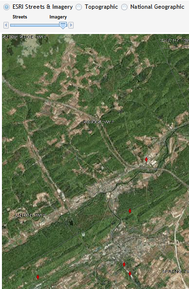
Select Base Map
The Select Base Map
toolbar allows the user to choose the base layer for the AUL map.
To choose a base layer, click the radio button in front of the layer
name. The selected layer will be displayed as the base
map. The default layer is the ESRI Streets & Imagery layers.
·
ESRI
Streets & Imagerys
§ Streets:
This worldwide street map presents highway-level data for the world and
street-level data for the United States, Canada, Japan, Southern Africa, most
countries in Europe, and several other countries. This comprehensive street map
includes highways, major roads, minor roads, one-way arrow indicators,
railways, water features, administrative boundaries, cities, parks, and
landmarks, overlaid on shaded relief imagery for added context. The map also
includes building footprints for selected areas in the United States and Europe
and parcel boundaries for much of the lower 48 states.
§ The street map was developed by Esri using Esri basemap
data, DeLorme basemap layers, Automotive Navigation
Data (AND) road data, U.S. Geological Survey (USGS) elevation data, UNEP-WCMC
parks and protected areas for the world, Tele Atlas Dynamap®
and Multinet® street data for North America and
Europe, and First American (CoreLogic) parcel data
for the United States. Coverage for street-level data in Europe includes Andorra,
Austria, Belgium, Czech Republic, Denmark, France, Germany, Great Britain,
Greece, Hungary, Ireland, Italy, Luxembourg, Netherlands, Norway, Poland,
Portugal, San Marino, Slovakia, Spain, Sweden, and Switzerland. Coverage for
street-level data elsewhere in the world includes China (Hong Kong only),
Colombia, Egypt (Cairo only), Indonesia (Jakarta only), Japan, Mexico, Russia,
South Africa, Thailand, and Turkey (Istanbul and Ankara only).
- Imagery: This map
presents low-resolution imagery for the world and high-resolution
imagery for the United States and other metropolitan areas around the
world. The map includes NASA Blue Marble: Next Generation 500m
resolution imagery at small scales (above 1:1,000,000), i-cubed 15m eSAT imagery
at medium-to-large scales (down to 1:70,000) for the world, and USGS
15m Landsat imagery for Antarctica. It also includes 1m i-cubed Nationwide Select imagery for the
continental United States, and GeoEye IKONOS
1m resolution imagery for Hawaii, parts of Alaska, and several hundred
metropolitan areas around the world.
·
National Geographic: This Internet-based map service combines a
century-old cartographic tradition with GIS technology. Created by the National Geographic Society
in cooperation with Esri, it provides a basemap for users who want to display
minimal data against a vibrant, detailed background.
This reference map includes physical
and natural features, administrative boundaries, cities, transportation
infrastructure, landmarks, protected areas, ocean floors, and other layers.
Shaded relief and land-cover imagery supply added context. Global coverage is
available to 1:144,000 scale, and more detailed
coverage, down to 1:9,000, is available in urban areas in North America. The
map uses data from a variety of leading data providers including DeLorme, NAVTEQ, UNEP-WCMC, NASA, ESA, and USGS.
·
Topo: This map was compiled to uniform cartography
using a variety of best available sources from several data providers,
including the U.S. Geological Survey, U.S. Environmental Protection Agency,
U.S. National Park Service, Food and Agriculture Organization of the United
Nations (FAO), Department of Natural Resources Canada (NRCAN), Agriculture and Agri-Food Canada, the State of Arkansas, Tele Atlas,
Automotive Navigation Data (AND), DeLorme, and ESRI.
The
service currently provides coverage for the world down to a scale of ~1:144k,
coverage for the continental United States and Hawaii from a scale of ~1:9.2m
down to ~1:18k, coverage for Arkansas from a scale of ~1:577k down to ~1:4.5k,
coverage for Canada and Western Europe from a scale of ~1:72k down to ~1:18k,
coverage for selected cities in Western Europe down to ~1:5k, and coverage for
Hong Kong and Macau from a scale of ~1:72,000 down to ~1:1,000.
If the ESRI Street and Imagery
Layer is selected, a slider will be visible to adjust
the transparency of the layers.
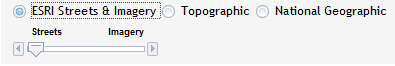
The closer the slider is to the
layer name, the less transparent the layer will appear. The farther
away the slider is from the layer name, more transparent the layer will become.
See examples below