Buffer a Polyline
Buffer a Polyline is used to buffer a line on the map.
Follow the steps below to buffer a
polyline.
- Select the Tasks tab on the left side of the
screen.
![]()
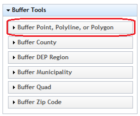
2.
Click on Buffer Tools to
display menu if necessary.

- Click on Buffer Point, Polyline, or Polygon
- The Point, Polyline, or Polygon buffer box will be
displayed.

o Click on Polyline to select a polyline buffer.
o A distance for the buffer needs to be specified.
As an example, a buffer distance of 1 mile will calculate one mile
on all sides of the drawn polyline. The
distance is measured according to the unit that is selected from drop down box.
The default is miles. The buffer distance entered must be greater
than 0.
- When finished entering the buffer parameters, click
the "Create Buffer" button.
- Draw a
polyline on the map. Do this by clicking a point to start and then
click subsequent points on the map to draw a line. Double-click to
complete the line. Once the line is drawn, the buffer will be
created. The buffer appears as a red shaded area. AULs
within the buffered zone appear as
 . Buffer result
attributes will be displayed in the bottom of the application.
. Buffer result
attributes will be displayed in the bottom of the application.

- Move the buffer grid scroll bar if necessary to the
right to show the Display Documents.

- Click the
 button to display the selected row AUL
documents.
button to display the selected row AUL
documents.

1.
Click the ![]() button to display the selected document.
button to display the selected document.

- Click the
 icon
to zoom the map to the selected row AUL location.
icon
to zoom the map to the selected row AUL location.

- The Clear Selection
tool
 can
be used to clear buffer results.
can
be used to clear buffer results.