DEP's Environmental Site
Assessment Search Tool allows consultants conducting Phase I environmental site
assessments and interested members of the public access to information
maintained by DEP concerning permitting, licensing, inspection, compliance,
discharges of pollution, regulated storage tanks, site remediation, and
enforcement. Consultation with DEP's Environmental Site Assessment Search Tool
is a means of identifying activities of potential environmental concern. It is
not a substitute for an environmental assessment conducted by a qualified
professional.
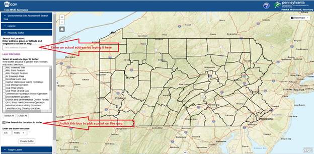
Below are guidelines for
performing a search for Activity layers (e.g. xyz) with in a distance (or buffer) from either a user-supplied
address or by clicking a map on a specific point on the map. The result of the search will include all the
details of the activity layer, xyz, that are available.
Once the results are
presented a user can choose to:
1) Make an informal request for additional information
2) Produce a summary report on DEP letterhead
3) Print/view
a table summary of all data for an activity
4) Export
an activiity information to the desktop
5) export
all activity information to the desktop
Other quick reference
links are below:
o
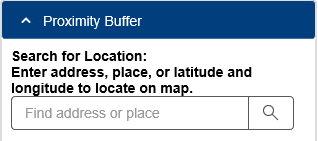
Type an address in the “find address or place” field and click search
·
![]()
![]()
·
![]()
![]()
![]()
(use the ctrl key and click to hyper link titles above)
The user can search for a target address by using there two methods:
1) Enter an actual street address
2) Pick a point on the map
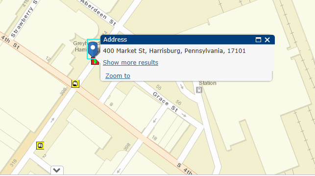
For example: Here 400 Market St, Harrisburg, PA was entered in the address field.
The address appears on the map and icons for previously identified activity layers appear.
This feature also allows the user to enter a partial address and a suggested street address will appears.
The ‘Use Search for Location to buffer’ is always clicked so the User can search activities by the street address provided.

To do a target address search by picking a point on the map, the User will need to unclick the ‘Use Search for Location to buffer’ box shown below.
![]()
Will appear as:
![]()
The user will then use the mouse to click a point on the map. The user will use the mouse to zoom in and out of the map. As the user zoom into the map, detailed street names will appear and the user can click on this area of interesting.
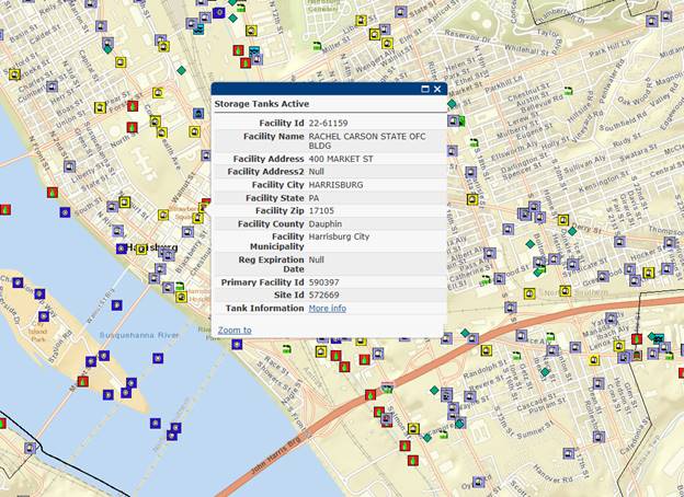
An example of the map detail provided on a pick a point search for 400 market Street is below.
Search by Activity layer (or Layer to buffer)
1) Select the Activity Layer or Environmental Assessment area interested reviewing for the address entered above by click on the box to the left of the activity title.
2) Select one or more Activity Layers if the radius (or buffer) around the target address is less than 10miles. For an assessment +10miles only one Activity Layer at time can be chosen.
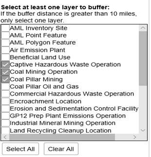
A complete list of activity layers in available at the end of the guide.
3) Click the box to the left of the Activity Layer to search the layer that applies.
![]() to include all criteria.
to include all criteria.
![]() to clear selections and start over
to clear selections and start over
4) Enter the desired radius (or buffer) in feet or miles around the target address that is being assessed.

5) Click the ‘Create Buffer’ box to complete search
![]()
The search result will be summarized in a separate window for the target address.
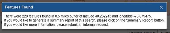
Click on ‘x’ in the upper right corner to get to detailed map layer and tables in the background

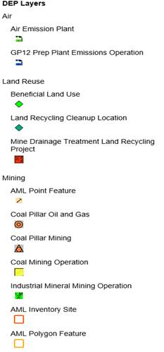
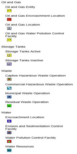
A detailed description of the map icons can be found in the legends of the quick reference guide.
Below the results map is a table of all the information retrieved in the search
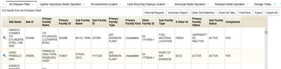
Each Activity layer is placed in a separate tab for a detailed review of each activity.
For example, to retrieve the ‘Captive hazardous Waste Operations’ details, click on the tab with that title.
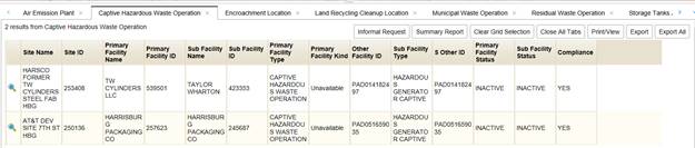
The details within each Activity can be reviewed and a request for documentation can be generated. These actions include:
Submit a more formal request for this sites DEP’s history by click on this button.
![]()
A form will appear that looks like this:

This tab generates a summary of the assessment activities on DEP Letter head.
![]()
To create the official documentation, enter the contact information to display on Summary Report heading.
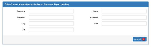
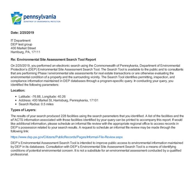
Once the contact information is entered, click’s on the ‘generate’ button and a summary of the search activities will be displayed in a pdf letter format. This can be printed, saved, or sent to interested parties.
A sample of the letter is below:
To clear the gridlines on the map above, click on the ‘clear grid’ button.
![]()
To close all the table tabs and review only the map, click on the ‘close all tabs’ button
![]()
To print a summary of the table results, click on the print/view button and a view of the activity table details will open in a web page. This page can be printed.
![]()
The information provided in the Activity tab can be export to a .csv file for formulating a more focused and targeted request. Click on this tab to save the summary table to the desktop.
![]()

The information provided for all the Activities listed on all the tabs with results can be exported to a .csv file for formulating a more focused and targeted request. Click on the tab ‘export all’ to save a summary table of all the search Activities to the desktop.
![]()

Before the target address search the legends box includes mapping icons:

The Legend Icon displayed when the target address is entered include:
|
|
|

|
LAYER NAME |
LAYER BRIEF DESCRIPTION |
|
AML
Inventory Site |
The
AML (Abandoned Mine Land) Inventory is a collection of areas where surface
features of abandoned mines are present. Presently the data is shown using
three layers. AML Inventory Sites is used to show the entire boundary of a
problem area. AML Points and AML Polygons are used to show specific problems
within a designated inventory site. The inventory Does Not Include complete
and comprehensive coverage of abandoned underground mines, surface or
underground mines that were permitted and closed after 1982, or active
surface or underground mines. For further information concerning mining in
your area, please contact the local DEP office. |
|
AML
Point Feature |
This
data set portrays the approximate location of Abandoned Mine Land Problem
Areas containing public health, safety, and public welfare problems created
by past coal mining. It is a subset of data contained in the Office of
Surface Mining (OSM) Abandoned Mine Land Inventory. This layer identifies AML
Points representing specific locations within an AML Inventory Site, examples
include AML discharge. |
|
AML
Polygon Feature |
This
data set portrays the approximate location of Abandoned Mine Land Problem
Areas containing public health, safety, and public welfare problems created
by past coal mining. It is a subset of data contained in the Office of
Surface Mining (OSM) Abandoned Mine Land Inventory. This layer identifies AML
Polygons representing specific areas to large too be represented by points
within the entire, AML Inventory Site, examples include AML dangerous
highwalls. |
|
Air
Emission Plant |
Air
Emissions Plant is a DEP primary facility type related to the Air Quality
Program. The sub-facility types related to the Air Emissions Plant that are
included in eMapPA are: Air Pollution Control Device, Combustion Unit, Fuel
Material Location, General Administrative Location, Incinerator, Point of Air
Emission, and Process. |
|
Beneficial
Land Use |
Beneficial
Land Use is a DEP primary facility type related to the Water Pollution
Control Program. The sub-facility type related to Beneficial Land Use is the
Parcel. A parcel refers to the land application site that is proposed to
received biosolids or residential septage. Land application for biosolids and
septage means beneficial use, meaning it is applied to land as a soil
amendment/fertilizer. |
|
Captive
Hazardous Waste Operation |
A
Captive Hazardous Waste Operation is a DEP primary facility type related to
the Waste Management Hazardous Waste Program. The sub-facility types related
to Captive Hazardous Waste Operations that are included in eMapPA are:
Boiler/Industrial Furnace, Disposal Facility, Hazardous Generator,
Incinerator, Recycling Facility, Storage Facility, and Treatment Facility. |
|
Coal
Mining Operation |
A
Coal Mining Operation is a DEP primary facility type related to the Mining
Program. The sub-facility types related to Coal Mining Operations that are
included in eMapPA are: Coal-Aboveground
Storage Tank - aboveground tanks greater than 250 gallons used to store a
regulated substance, motor oil or fuel on a coalmine permit. These tanks are
regulated under the coal mining regulations since they are specifically
exempted from the storage tank regulations.
Discharge Point - Discharge of water from an area as a result
of coal mining activities. Mineral Preparation Plant - Facility at
which coal is cleaned and processed. Mining Stormwater GP - General
permit for Stormwater discharges associated with coal mining activities in
which the main pollutant is sediment. Discharge is not into a High Quality or
Exceptional Value designated stream. NPDES
Discharge Point - An effluent discharge at a coal mine operation
permitted under the National Pollutant Discharge Elimination System. Post Mining Treatment - Post-mining
discharges are groundwater seeps and flows that occur after a mine has been
completed and reclaimed. Many of these discharges have become contaminated by
contacting acid producing rock in the mine environment. Untreated discharges
that enter clean streams cause acidification, which immediately kills much of
the aquatic life. Coal mines that are predicted to have discharges are not
permitted; however, coal mining operators are required to treat post-mining
discharges in cases where the predictions do not come true. Through advances
in predictive science, less than 2 percent of the permits issued today result
in a post-mining discharge. New technologies, including alkaline addition and
special handling of acid producing material, are being studied in order to
help address the remaining 2 percent. Refuse
Disposal Facility - An area used for disposal or storage of waste coal,
rock, shale, slate, clay, and other coal mining related materials. Refuse Reprocessing - Facility at
which coal is extracted from waste coal, rock, shale, slate, clay, and other
coal mining related material, i.e., coal refuse. Surface Mine - Surface mining of coal by
removing material which lies above the coal seam. Includes, but is not limited to, strip,
auger, quarry, dredging and leaching mines.
Underground Mine - Deep mining of coal. Includes, but is not limited to, portal,
tunnel, slope and drift mines. |
|
Coal
Pillar Mining |
Coal
Pillar Locations are pillars of coal that must remain in place to provide
support for a coal mine. |
|
Coal
Pillar Oil and Gas |
Coal
Pillar Locations are pillars of coal that must remain in place to provide
support for a coal mine. |
|
Commercial
Hazardous Waste Operation |
A
Commercial Hazardous Waste Operation is a DEP primary facility type related
to the Waste Management Hazardous Waste Program. The sub-facility types
related to Commercial Hazardous Waste Operations that are included in eMapPA
are: Disposal Facility, Hazardous Generator, Recycling Facility, Storage
Facility, and Treatment Facility. |
|
Encroachment
Location |
An
Encroachment Location is a DEP primary facility type related to the Water
Resources Management Water Obstructions Program. There are many sub-facility
types relating to Encroachment Locations, ranging from Boat Launch Ramps to
Dredging to Wetland Impact, that are included in eMapPA. Furthermore, these
sub-facilities may pertain to more than one primary facility kind as listed:
Abandoned Mine Reclamation, Mineral Resources, Oil and Gas, Soils and
Waterways, Waterways Engineering, and Water Quality. |
|
Erosion
and Sedimentation Control Facility |
An
Erosion and Sediment Control Facility is a DEP primary facility type related
to the Water Pollution Control program. The following is a list of
sub-facility types related to Erosion and Sediment Control Facilities that
are included in eMapPA: Agricultural Activities, Commercial or Industrial
Development, Government Facilities, Oil and Gas Development, Private Road or
Residence, Public Road Construction, Recreational Activities,
Remediation/Restoration, Residential Subdivision, Sewerage or Water Systems,
Silviculture, or Utility Facility and/or Transmission Line. Any of the above development activities that
may discharge stormwater during construction fall under the erosion and
sediment control permit category. |
|
GP12
Prep Plant Emissions Operation |
Mineral
Preparation Plants with an Air Quality General Permit inspected by District
Mining Operations staff for compliance with Air Quality Regulations. |
|
Industrial
Mineral Mining Operation |
An
Industrial Mineral Mining Operation is a DEP primary facility type related to
the Industrial Mineral Mining Program. The sub-facility types included in
eMapPA are: Deep Mine - Underground mining of industrial minerals,
i.e., noncoal mining. Includes, but is
not limited to, industrial minerals extracted from beneath the surface by
means of shafts, tunnels, adits or other mining openings. Discharge Point - Discharge of water
from an area as a result of industrial mining activities, i.e. noncoal
mining. Mineral Preparation Plant - Facility at which industrial
minerals (i.e. noncoal minerals) are cleaned and processed. Mining
Stormwater GP - General permit for Stormwater discharges associated with
industrial mineral mining activities in which the main pollutant is
sediment. Discharge is not into a High
Quality or Exceptional Value designated stream. NPDES Discharge Point -
National Pollutant Discharge Elimination System effluent discharge point for
Industrial Mineral (Noncoal) Mine Sites.
Post Mining Treatment - Inactive Industrial Mine with a
permitted treatment facility. Surface Mine - Surface mining of
industrial minerals (i.e. noncoal minerals) by removing material which lies
about the industrial minerals.
Includes, but is not limited to, strip, augur, quarry, dredging and
leaching mines. |
|
Land
Recycling Cleanup Location |
Land
Recycling Cleanup Location Land Recycling Cleanup Locations (LRCL) are
divided into one or more sub-facilities categorized as media: Air, Contained
Release or Abandoned Container, Groundwater, Sediment, Soil, Surface Water,
and Waste. Media is the environmental resource that is associated with the
cleanup effort. The following primary facility kinds describe the Acts from
which cleanup locations are derived: Act2 Land Recycling and Environmental
Remediation Standards The first declaration of Section 102 of the policy
provides a brief description of the purpose of Act2: The elimination of
public health and environmental hazards on existing commercial and industrial
land across this Commonwealth is vital to their use and reuse as sources of
employment, housing, recreation, and open-space areas. The reuse of
industrial land is an important component of a sound land use policy that
will help prevent the needless development of prime farmland, open-space
areas and natural areas and reduce public costs for installing new water,
sewer, and highway infrastructure. CERCLA Comprehensive Environmental
Response, Compensation, and Liability Act, also known as the Superfund This
act was passed by Congress as a federal law in December of 1980, creating a
tax on chemical and petroleum industries to: Identify and respond to sites
from which releases of hazardous substances into the environment have
occurred or could potentially occur Ensure they are cleaned up by responsible
parties or through government funding Evaluate damages to natural resources
HSCA Hazardous Sites Cleanup Act [This Act] provides the Department of Environmental
Protection (DEP) with the funding and the authority to conduct cleanup
actions at sites where hazardous substances have been released. HSCA also
provides DEP with enforcement authorities to force the persons who are
responsible for releases of hazardous substances to conduct cleanup actions
or to repay public funds spent on a DEP funded cleanup action. HSCA funds are
also used to pay the state share of costs of cleanup actions at Pennsylvania
sites in the Federal Superfund program. Under the provisions of HSCA, most
HSCA sites involve bankrupt facility owners, abandoned facilities, and
inappropriate disposal of hazardous substances. As a general rule, HSCA sites
do not include active facilities with financially viable owners. Other The
Other primary facility kind includes a mixture of various different cleanup
sites, no further action sites, and potential sites. This is optional data
that the regional offices are not required to maintain. STSP Storage Tank
Spill and Prevention Act Releases and/or ruptures from improperly installed
or faulty storage tanks contaminate the Commonwealth's land and water
resources. This act was passed to prevent such contamination through
"improved safeguards on the installation and construction of storage
tanks." |
|
Mine
Drainage Treatment Land Recycling Project |
Mine
Drainage Treatment/Land Reclamation Locations are clean-up projects that are
working to eliminate some form of abandoned mine. |
|
Municipal
Waste Operation |
A
Municipal Waste Operation is a DEP primary facility type related to the Waste
Management Municipal Waste Program. The sub-facility types related to
Municipal Waste Operations that are included in eMapPA are: Composting, Land
Application, Abandoned Landfills, Active Landfills, Processing Facility,
Resource Recovery, and Transfer Station. |
|
Oil
and Gas Encroachment Location |
An
Encroachment Location for Oil & Gas is a DEP primary facility type
related to the Oil and Gas Program. The sub-facilities that fall under Oil
and Gas Encroachment also exist under Encroachment Locations. The difference is
in the DEP program that regulates the facilities. |
|
Oil
and Gas Entity Oil
and Gas Location |
An Oil and Gas Location is a DEP primary facility type
related to the Oil & Gas Program. The sub-facility types related to Oil
and Gas that are included in eMapPA are: Land Application -
An Area Where drilling cuttings or waste are disposed by land
application. Pit - An approved pit that is used for storage of oil and gas
well fluids. Well - A well associated with oil and/or gas production. |
|
Oil
and Gas Water Pollution Control Facility |
An
Oil and Gas Water Pollution Control Facility is a DEP primary facility type
related to the Oil & Gas Program. The following are the sub-facility
types related to Water Pollution Control that are included in eMapPA: Discharge
point - The outfall from a wastewater treatment facility for oil and gas
fluids. Internal Monitoring Point
- A monitoring point within the wastewater treatment system where samples are
collected. Treatment Plant - A
facility for treating oil and gas wastewater to achieve permit effluent
limits. |
|
Residual
Waste Operation |
A
Residual Waste Operation is a DEP primary facility type related to the Waste
Management Residual Waste Program. Residual waste is waste generated at an
industrial, mining, or wastewater treatment facility. The sub-facility types
related to Residual Waste that are included in eMapPA are: Generator,
Impoundment, Incinerator, Land Application, Landfill, Processing Facility,
and Transfer Station. |
|
Storage
Tanks Active |
A
Storage Tank Location is a DEP primary facility type, and the storage tanks
at the facility are the sub-facilities. Active storage tanks are
aboveground or underground tanks regulated under the Storage Tank and Spill
Prevention Act (35 P.S. §6021) and 25 Pa. Code Chapter 245. Active
storage tanks are in a status of “currently in use” or “temporarily out of
use”, which means the tanks still exist in a regulated status. These
tanks are currently registered to hold a regulated substance, which could be
a petroleum product or a hazardous substance. Aboveground storage tanks
with a capacity greater than 21,000 gallons, and aboveground storage tanks
that contain highly hazardous substances, are removed from this layer. |
|
Storage
Tanks Inactive |
A
Storage Tank Location is a DEP primary facility type, and the storage tanks
at the facility are the sub-facilities. Inactive storage tanks are
aboveground or underground tanks that were once regulated under the Storage
Tank and Spill Prevention Act (35 P.S. §6021) and 25 Pa. Code Chapter
245. Inactive storage tanks include those tanks that have been removed,
permanently closed, exempted from regulation, transferred to a different
facility record, or otherwise removed from registration with DEP. These
tanks previously held a regulated substance, which could have been a
petroleum product or a hazardous substance. |
|
Water
Pollution Control Facility |
A
Water Pollution Control Facility is a DEP primary facility type related to
the Water Pollution Control Program. The sub-facility types related to Water
Pollution Control that are included in eMapPA are: Agricultural Activities - The
management and use of farming resources for the production of crops,
livestock or poultry. Biosolids
Treatment - Indicates that the facility treats sewage sludge to produce a
material that can be beneficially used, biosolids. Compost/Processing - Indicates that
the facility treats sewage sludge by composting to produce a material that
can be beneficially used, biosolids. Conveyance
System - Sewage system without treatment.
Discharge Point - Discharge point to stream. Groundwater Monitoring Point. Internal Monitoring Point - Used to
monitor internal processes - not a discharge.
Land Discharge - Land application of wastewater. Manure Management - Activities
related to or supporting storage, collection, handling, transport,
application, planning, record keeping, generation or other manure management
activities. Outfall structure - Outfall structure to stream. Pesticide Treatment Area - These SFs are
created to address treatment areas that in reality are often an entire water
body, such as a pond. The lat/long
coordinates are supposed to be entered at the mid-point or center of the
treatment area. Pipeline or Conduit
- Pipes or other smaller diameter conveyances that are used to transport or
supply liquids or slurries from collection, storage or supply facilities or
areas to other facilities or areas for storage, modification or use. These can be for longer-term, medium-term
or short-term and would include design, capacity, maintenance, safety,
inspection, accident and varying use and weather considerations. Production Service Unit - Catch all
sub-facility that covers a variety of industries participating in a multitude
of activities such as concentrated animal feeding, pharmaceuticals, paper,
steel, utilities, etc. The majority of
PSUs are classified as Industrial Waste or Stormwater-Industrial (Primary Facility
kind). Pump Station - Sewage
pump station. Septage Land
Application - Indicates that the septage hauler treats residential
septage for land application, meaning that it can be applied to land as a
soil amendment/fertilizer. Storage
Unit - Storage of wastewater. Treatment
Plant - Sewage or industrial wastewater treatment plant. |
|
Water
Resources |
A
Water Resource is a DEP primary facility type related to the Water Use
Planning Program. The sub-facility types related to Water Resources that are
included in eMapPA are: Discharge, Ground Water Withdrawal, Interconnection,
Storage, Surface Water Withdrawal, and Water Allocation. |